


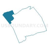
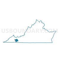
Saltville Voting District, Smyth County, Virginia
About
Outline

Summary
| Unique Area Identifier | 682545 |
| Name | Saltville Voting District |
| County | Smyth County |
| State | Virginia |
| Area (square miles) | 44.85 |
| Land Area (square miles) | 44.56 |
| Water Area (square miles) | 0.29 |
| % of Land Area | 99.34 |
| % of Water Area | 0.66 |
| Latitude of the Internal Point | 36.91347480 |
| Longtitude of the Internal Point | -81.75421300 |
Maps

Graphs
Select a template below for downloading or customizing gragh for Saltville Voting District, Smyth County, Virginia


Neighbors
Neighoring Voting District (by Name) Neighboring Voting District on the Map
- Chilhowie Voting District, Smyth County, VA
- Clinchburg Voting District, Washington County, VA
- Elk Garden Voting District, Russell County, VA
- Freestone Voting District, Tazewell County, VA
- Hayter's Gap Voting District, Washington County, VA
- Rich Valley Voting District, Smyth County, VA
- Seven Mile Ford Voting District, Smyth County, VA
- Thompson Valley Voting District, Tazewell County, VA
- Wardell Voting District, Tazewell County, VA
Top 10 Neighboring County Subdivision (by Population) Neighboring County Subdivision on the Map
- Lebanon district, Russell County, VA (14,477)
- Southern district, Tazewell County, VA (9,101)
- Jefferson district, Washington County, VA (7,584)
- Chilhowie district, Smyth County, VA (4,811)
- North Fork district, Smyth County, VA (4,392)
- Saltville district, Smyth County, VA (4,315)
Top 10 Neighboring Place (by Population) Neighboring Place on the Map
Top 10 Neighboring Unified School District (by Population) Neighboring Unified School District on the Map
- Washington County Public Schools, VA (54,876)
- Tazewell County Public Schools, VA (45,078)
- Smyth County Public Schools, VA (32,208)
- Russell County Public Schools, VA (28,897)
Top 10 Neighboring State Legislative District Lower Chamber (by Population) Neighboring State Legislative District Lower Chamber on the Map
- State House District 4, VA (73,375)
- State House District 5, VA (69,572)
- State House District 2, VA (69,063)
- State House District 3, VA (66,212)
Top 10 Neighboring State Legislative District Upper Chamber (by Population) Neighboring State Legislative District Upper Chamber on the Map
Top 10 Neighboring 111th Congressional District (by Population) Neighboring 111th Congressional District on the Map
Top 10 Neighboring Census Tract (by Population) Neighboring Census Tract on the Map
- Census Tract 103, Washington County, VA (6,949)
- Census Tract 302, Smyth County, VA (4,658)
- Census Tract 107, Washington County, VA (4,480)
- Census Tract 206, Tazewell County, VA (4,358)
- Census Tract 301, Smyth County, VA (3,427)
- Census Tract 304.02, Russell County, VA (3,065)
Top 10 Neighboring 5-Digit ZIP Code Tabulation Area (by Population) Neighboring 5-Digit ZIP Code Tabulation Area on the Map
- 24609, VA (7,630)
- 24319, VA (6,979)
- 24370, VA (6,572)
- 24651, VA (6,314)
- 24340, VA (5,657)
- 24377, VA (348)
- 24316, VA (50)